
Transport, Engineering and Movement
The “Transport, Engineering and Movement” chapter explores how the physical connectivity of London—from its historic river crossings to the world’s first underground railway—has defined the city’s expansion and global character. Moving beyond mere logistics, this sub-category examines the “Engineering of Ambition,” revealing how the Victorian drive to conquer space and time through infrastructure created the icons of modern urban life. To study these networks is to analyze the “Blueprint of a Global Hub,” showing how the constant movement of people and goods across the Thames and through the Tube has sustained London’s identity as a resilient and ever-evolving metropolis.
River Thames
The River Thames is the “Liquid History” of London, serving as the original reason for the city’s location and the primary artery for its global trade and power. From the Roman settlement of Londinium to the 19th-century “Workshop of the World,” the river has been the setting for royal pageantry, industrial toil, and radical social change. This sub-category examines the “Resilience of the Waterfront,” showing how the Thames moved from a polluted industrial drain to a vibrant cultural corridor. To explore the river is to witness the “Pulse of the Capital,” revealing how the ebb and flow of the tide continues to shape the economic and psychological landscape of British life.

- Tower Bridge: The world’s most famous bascule bridge and a masterpiece of Victorian engineering, serving as a soaring gateway to the Upper Pool of London. This bridge is located in the City of London/Southwark.
- The Thames Path: A 184-mile National Trail that follows the river through the heart of the city, providing a visceral look at the changing architectural layers of the waterfront. This path runs along both banks of the Thames.
- The London Bridge City: A modern commercial and leisure district that stands on the site of historic wharves, representing the 21st-century regeneration of the river’s edge. This district is located in Southwark.
- The Pool of London: The historic stretch of the river between London Bridge and Cherry Garden Pier, once the busiest port in the world and the heart of the British Empire’s trade. This site is located in the City of London.
- The Thames Barrier: One of the world’s largest movable flood barriers, representing the modern engineering required to protect the city from the rising power of the sea. This site is located in Woolwich.




Bridges of London
“Bridges of London” represents the “Sutures of the City,” the critical infrastructure that joined the disparate north and south banks into a single, unified capital. Each bridge, from the medieval “Old London Bridge” to the ultra-modern Millennium Bridge, reflects the architectural style and engineering capabilities of its era. This sub-category examines the “Evolution of Connection,” showing how these structures moved from sites of commerce and defense to symbols of urban beauty and public space. To study London’s bridges is to analyze the “Physical Links of Identity,” revealing how the city has consistently bridged the gap between its ancient heritage and its future aspirations.
- London Bridge: The site of the first-ever bridge across the Thames, built by the Romans; the modern 1970s structure stands where a medieval “city on a bridge” once existed. This bridge is located in the City of London.
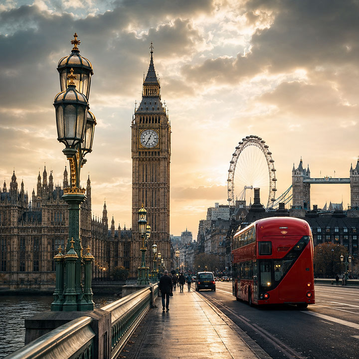
- Westminster Bridge: A stunning green-painted bridge (matching the seats in the House of Commons) that provides the iconic view of the Houses of Parliament and Big Ben. This bridge is located in Westminster.
- The Millennium Bridge: Known as the “Wobbly Bridge,” this lateral suspension footbridge represents the avant-garde design of the year 2000 and links St Paul’s to Tate Modern. This bridge is located in the City of London/Southwark.
- Albert Bridge: One of London’s most beautiful and ornate suspension bridges, famous for its elaborate lighting and the “dimiss troops” sign from its unstable early history. This bridge is located in Chelsea/Battersea.
- Southwark Bridge: A classic arched bridge that offers a unique perspective on the city’s historic financial district and the reconstructed Globe Theatre. This bridge is located in the City of London/Southwark.
Canals and Docks
The “Canals and Docks” chapter explores the “Industrial Waterways” of London, serving as the hidden logistics network that fueled the city’s expansion during the 18th and 19th centuries. While the Thames was the primary artery of global trade, the canals and enclosed docks represented the internal machinery of the Empire, allowing for the secure storage and transport of high-value goods like tea, silk, and spices. This sub-category examines the “Architecture of the Quayside,” revealing how the massive high-walled warehouses and deep-water basins transformed East London into the “Warehouse of the World.” To visit these sites is to analyze the “Physical Scale of the Industrial Age,” showing how the shift from river-based to inland docks accelerated the pace of international commerce and reshaped the urban landscape forever.
- St Katharine Docks: A historic dock designed by Thomas Telford and Philip Hardwick, known for its elegant warehouses and its role as a secure repository for luxury goods near the Tower of London. This dock is located in the London Borough of Tower Hamlets.
- The Museum of London Docklands: Housed in a historic 19th-century warehouse at West India Quay, this museum is the definitive site for exploring the history of the river, the trade in sugar and slavery, and the life of the dockworkers. This museum is located in West India Quay.
- Regent’s Canal (Little Venice): A tranquil inland waterway that represents the 19th-century engineering feat of connecting the Grand Junction Canal to the River Thames, now a vibrant center for narrowboat culture. This canal is located in Maida Vale/Paddington.
- Canary Wharf (West India Docks): Once the busiest part of the port of London, this site now represents the peak of urban regeneration, where modern financial towers stand on the foundations of the Victorian rum and sugar docks. This district is located in the Isle of Dogs.
- The Wapping Hydraulic Power Station: A preserved industrial landmark that once provided the high-pressure water required to operate the cranes and lock gates of the nearby docks. This site is located in Wapping.
- The Bascule Bridge (Shadwell): A rare surviving example of the mechanical engineering used to manage the movement of ships and pedestrians within the complex dock systems of the East End. This bridge is located in Shadwell.
Railways and Stations
The “Railways and Stations” chapter explores the “Industrial Arteries” of London, serving as the definitive catalyst for the city’s expansion from a compact core into a sprawling global metropolis. Moving beyond mere transport hubs, this sub-category examines the “Cathedrals of Steam”—the massive Victorian termini that projected the wealth and architectural ambition of competing railway companies. This study reveals the “Blueprint of Suburban Growth,” showing how the iron roads allowed for the first mass-movement of people between the city and its surrounding counties, fundamentally changing the social and economic fabric of Britain. To explore these stations is to witness the “Infrastructure of Modernity,” revealing how London’s rail network continues to synchronize the life of millions every day.
- St Pancras International: A masterpiece of Victorian Gothic architecture by George Gilbert Scott, serving as the “Gateway to Europe” and a soaring symbol of the mid-19th-century railway boom. This station is located in Euston Road.
- King’s Cross Station (Platform 9 ¾): A major transport hub and now a global pilgrimage site for the “London of the Imagination,” representing the intersection of 19th-century infrastructure and modern cinematic branding. This station is located in Euston Road.
- Paddington Station: Isambard Kingdom Brunel’s functional masterpiece, designed to be the grand entrance for the Great Western Railway and a monument to the peak of British civil engineering. This station is located in Paddington.
- Liverpool Street Station: A historic site that served as the primary arrival point for the Kindertransport during WWII, acting as a visceral site of humanitarian memory and wartime endurance. This station is located in the City of London.
- The Windrush Line (London Overground): A modern railway naming that honors the post-war Caribbean community whose arrival fundamentally reshaped the culture and identity of East and South London. This line serves stations across London.
- Waterloo Station: The UK’s busiest railway station and the setting for the Windrush Statue, celebrating the generation that arrived in 1948 to rebuild a post-war Britain. This station is located in Waterloo.
London Underground
The “London Underground” chapter explores the “Pioneering Subterranean World,” serving as the world’s first-ever underground railway system. Established in 1863 to alleviate Victorian street congestion, the “Tube” fundamentally changed the city’s relationship with time and space, allowing London to expand far beyond its original limits. This sub-category examines the “Engineering of the Deep,” analyzing how the shift from cut-and-cover steam-powered tunnels to deep-level electric “tubes” created a global blueprint for urban transit. To study this network is to witness the “Iconography of Movement,” revealing how the iconic map, the roundel, and the distinctive “Mind the Gap” warnings have become universal symbols of London’s efficiency and character.
- Baker Street Station: One of the original stations of the 1863 Metropolitan Railway, featuring a historic platform that retains its Victorian architecture and celebrates its fictional resident, Sherlock Holmes. This station is located in Marylebone Road.
- Paddington Station: The terminus for the first underground line to Farringdon, representing the site where Victorian steam technology first moved beneath the city streets. This station is located in Paddington.
- Farringdon Station: The eastern terminus of the world’s first underground journey, now a major intersection for modern infrastructure projects like the Elizabeth Line. This station is located in Cowcross Street.
- 23-24 Leinster Gardens: A unique site featuring “dummy houses” built with fake facades to disguise the open-air sections where early steam-powered underground trains vented their smoke. This site is located in Paddington.
- The Windrush Line (London Overground): A repurposed section of the 1843 Thames Tunnel—originally the world’s first tunnel under a navigable river—now honoring the post-war Caribbean community. This line serves stations between Wapping and Rotherhithe.
- The London Transport Museum: Housed in a Victorian flower market, it serves as the definitive repository for historic Tube carriages, posters, and the evolving design of the world’s most famous transport map. This museum is located in Covent Garden.
Airports and Global London
“Airports and Global London” explores the city’s 21st-century status as the world’s most connected aviation hub, where the physical boundaries of the island nation are bridged by high-speed global transit. Moving from the historic airfield at Croydon to the massive high-tech complexes of Heathrow and Gatwick, this chapter examines the “Logistics of a World City,” analyzing how the constant flow of international visitors, business, and migration sustains London’s economic power. To study these gateways is to witness the “Scale of Modern Movement,” revealing how airports serve as the primary reception rooms for the diverse global identities that continuously redefine Britain’s contemporary character.
- Heathrow Animal Reception Centre: A specialized facility that manages the arrival of thousands of animals annually—from domestic pets to exotic reptiles—reflecting London’s role as a major global port. This centre is located in Heathrow Airport.
- Croydon Airport Visitor Centre: The historic site of London’s first major international airport, featuring the world’s oldest air traffic control tower and reflecting the early “Golden Age” of aviation. This centre is located in Purley Way, Croydon.
- IFS Cloud Cable Car: A modern aerial transport link over the Thames that provides a soaring perspective on the city’s eastern docklands and its 21st-century global connectivity. This attraction is located in the Royal Docks/North Greenwich.
- London City Airport: A unique urban airport built within the footprint of the former Royal Docks, symbolizing the successful regeneration of industrial maritime space into a high-speed business hub. This airport is located in the Royal Docks.
Brunel and Victorian engineering
The “Brunel and Victorian Engineering” chapter explores the “Golden Age of British Civil Engineering,” where visionary figures like Isambard Kingdom Brunel and his father, Marc, redefined the physical limits of the modern world. Moving from the construction of the first tunnel under a navigable river to the creation of massive iron steamships and sprawling railway networks, this sub-category examines the “Engineering of the Impossible.” It reveals how Victorian ambition fused scientific rigor with bold design to conquer space, time, and the elements. To study this branch is to analyze the “Framework of Modernity,” showing how the Brunels’ legacies in bridge-building, maritime travel, and rail infrastructure established Britain as the world’s primary laboratory for industrial progress.
- The Thames Tunnel: The world’s first tunnel under a navigable river (1843), pioneered by Marc Brunel and his son Isambard; it is now used by the London Overground as part of the Windrush Line. This tunnel is located between Wapping and Rotherhithe.
- Paddington Station: Isambard Kingdom Brunel’s functional masterpiece, designed as the grand terminus for the Great Western Railway and a soaring monument to the Victorian iron age. This station is located in Paddington.
- The SS Great Britain: Brunel’s revolutionary iron-hulled steamship, which represented the peak of 19th-century maritime engineering and the transformation of global travel. This ship is located in Bristol.
- Clifton Suspension Bridge: A spectacular example of Brunel’s bridge-building genius, serving as a soaring symbol of the industrial age’s aesthetic and structural ambition. This bridge is located in Bristol.
- Maidenhead Railway Bridge: Featuring the widest and flattest brick arches in the world, this bridge remains a functional testament to Brunel’s mastery of materials and geometry. This bridge is located in Maidenhead.
Transport and Urban Growth
“Transport and Urban Growth” explores the “Symbiotic Evolution” of London’s infrastructure and its physical expansion, analyzing how the development of the Tube, suburban railways, and bus networks allowed the city to break free of its medieval walls. This chapter examines the “Democratization of Movement,” revealing how the shift from a pedestrian-focused “Square Mile” to a sprawling “Metroland” fundamentally changed the social and economic character of the capital. To study this area is to decode the “Blueprint of a Global Hub,” showing how strategic transport planning turned remote villages into vibrant residential suburbs and sustained London’s identity as a resilient, connected metropolis.
- The London Transport Museum: Housed in a Victorian flower market, it is the definitive repository for the vehicles and designs that fueled London’s urban growth. This museum is located in Covent Garden.
- Metroland (Northwest London): The vast residential expansion triggered by the extension of the Metropolitan Line, representing the first major “commuter” landscapes of the 20th century. This area encompasses suburbs like Harrow and Wembley.
- The Boundary Estate: The world’s first council housing project, built in the shadow of new industrial transport links to provide a healthy urban alternative for the Victorian working class. This estate is located in Shoreditch.
- The Victoria Embankment: A massive 19th-century engineering project that reclaimed river land to house the District Line and new sewers, radically improving the city’s health and mobility. This site is located along the North Bank of the Thames.
- The Elizabeth Line: A 21st-century engineering marvel that has redefined urban connectivity, representing the future of London’s high-speed movement and growth. This line serves stations across London, from Reading to Abbey Wood.